Trails for everyone, forever

Home Go Hiking Hiking Guide Multnomah Falls

Multnomah Falls

Southwest Washington > Columbia River Gorge - OR
45.5774, -122.1167 Map & Directions
Length
1.2 miles, roundtrip
Elevation Gain
100 feet
Highest Point
611 feet
Calculated Difficulty About Calculated Difficulty
Easy
Photo courtesy WTA community. Full-size image
  • Dogs allowed on leash
  • Fall foliage
  • Good for kids
  • Rivers
  • Waterfalls
  • Wildflowers/Meadows

Parking Pass/Entry Fee

None
Saved to My Backpack

Multnomah Falls is one of the most beautiful (and popular) in the Columbia River Gorge. And that's saying something, since the Oregon side of the Gorge flows with more than 70 cascades of varying heights. Of course, all that flowing water has made it famous, and its proximity to Portland and Vancouver mean Multnomah is one of the most crowded of these waterfalls as well. Continue reading

Rating
3.60 out of 5

(10 votes) Log in to rate

Hiking Multnomah Falls

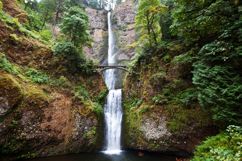
With more than 600 feet of water falling in a gorgeous horsetail, Multnomah Falls is one of the most beautiful (and popular) in the Columbia River Gorge. And that's saying something, since the Oregon side of the Gorge flows with more than 70 cascades of varying heights. Of course, all that flowing water has made it famous, and its proximity to Portland and Vancouver mean Multnomah is one of the most crowded of these waterfalls as well.

More than 2 million visitors flock to these falls every year. On a busy weekend, expect to see hundreds of your fellow hikers, not to mention family outings, tourists, even wedding parties, since the historic Benson Bridge across the upper splash pool is a favorite location for wedding photos, despite a handful of incidents in which rocks have come over the edge of the falls and crashed into the pool below. While quite rare, the effects of these exciting incidents range from thorough soakings of the wedding party to significant chunks being taken out of the bridge itself.

The hiking options here vary greatly. If you want an easy day, you can snap a few photos from the base of the falls, check out the informational kiosk at the base of the falls, then toddle to the gift shop/cafe for an ice cream cone. Or you can head up to Benson Bridge for a closer view of the waterfall. For a short, but rigorous hike, it's less than a mile to the overlook at the top of the falls, but be warned that the route is often crowded and always steep.

While the trail is quite wide, it is not ADA-accessible because of the grade. Mud near the top of the trail can also pose a bit of a threat be careful at that overlook!

On the way to the top, you'll hike through lush forest with ferns and moss growing on all sides. Maple and alder trees mix with Douglas-fir and redcedar and add a splash of color in the autumn. Wildflowers like False Solomon's Seal, foamflower, violets, and many others line the trail in spring.Multnomah Falls is spectacular year round, but go in winter or early spring to see the highest water flow.

Hike Description Written by
Multiple authors contributed to this report, WTA Community

Multnomah Falls

Map & Directions

Trailhead
Co-ordinates: 45.5774, -122.1167 Open in Google Maps

Before You Go

See weather forecast

Parking Pass/Entry Fee

None

WTA Pro Tip: Save a copy of our directions before you leave! App-based driving directions aren't always accurate and data connections may be unreliable as you drive to the trailhead.

Getting There

Coming from Portland, drive east on I-84 to exit 31 for Multnomah Falls. Park and walk underneath the interstate and railroad tracks to the Lodge and Visitor Center. You can also access the falls via exit 28 for Bridal Veil. This is three miles before the Multnomah Falls exit. This is a nice option if you want access to other trailheads, or you don't want to fight for a parking space near the falls.

Coming from the east, Travel west on Interstate 84 to exit 35 for Ainsworth State Park. Drive along the narrow Historic Highway west four miles to the site's parking area.

There is accessible parking available in both the upper and lower parking lots. Paved paths lead to the Visitor Center from both parking lots, but note that there are some slight inclines along the way from the parking lots to the visitor center and around the falls viewing area.

Get your timed-access permit if you're planning to visit here between May 24 and September 5, 2022.

take transit

This trailhead is accessible by bus! Plan your visit by bus using TOTAGO.

More Hike Details

Trailhead

Southwest Washington > Columbia River Gorge - OR

Larch Mountain (#441)

Columbia River Gorge National Scenic Area

You can improve or add to this guidebook entry!

Multnomah Falls

43 Trip Reports

Hiked here recently?

Submit a trip report!
 
Trip Reports